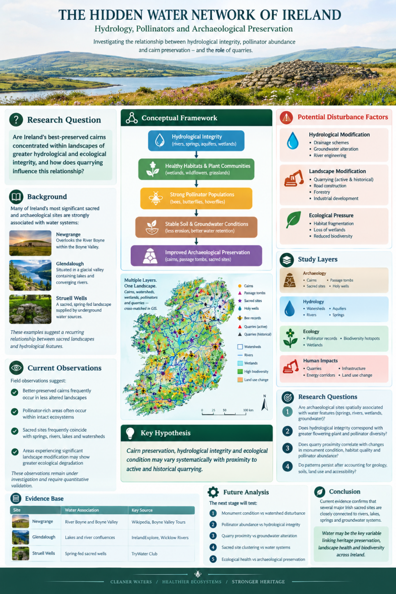
Hydrological Landscapes, Sacred Sites and Archaeological Preservation in Ireland
Can water help explain Ireland's ancient landscapes?
Ireland's archaeological landscape contains thousands of monuments, sacred places, holy wells, ancient burial sites, and ceremonial structures. Many of these places are also found in landscapes shaped by water.
Newgrange overlooks the River Boyne within the Boyne Valley. Glendalough occupies a dramatic glacial valley containing lakes, streams, and rivers. Struell Wells is a historic sacred well complex associated with natural springs. These examples raise an interesting question about whether the relationship between archaeological sites and water extends beyond their location and into the long-term condition of the surrounding landscape.
This project explores whether hydrological integrity may be associated with archaeological preservation and ecological health.
The aim is not to assume that water is responsible for the preservation of monuments or the health of ecosystems. Instead, the objective is to investigate whether measurable relationships exist between water systems, landscape disturbance, biodiversity, and archaeological condition.
The Central Research Question
Are Ireland's best-preserved cairns concentrated within the country's least-disturbed hydrological landscapes?
This is the central question guiding the research.
A related question is whether landscapes with greater hydrological and ecological integrity also support stronger populations and greater diversity of wild bees and other pollinators.
If relationships are identified, further research could investigate why they occur. If no significant relationship is found, that result would be equally important in understanding the factors that influence archaeological preservation and ecological health.
Why Look at Water?
Water has always been an important part of the Irish landscape. Rivers, springs, lakes, wetlands, and groundwater systems have influenced settlement, agriculture, movement, resource use, and cultural activity for thousands of years.
Water also affects the physical environment. Groundwater levels, drainage, soil moisture, erosion, vegetation, and wetland conditions can all change the character of a landscape.
Modern activities can alter these systems. Quarrying, drainage, intensive land use, infrastructure development, and other forms of landscape modification may affect surface water and groundwater conditions.
This does not mean that these activities have caused deterioration at particular archaeological sites. Establishing such a connection would require detailed evidence. The purpose of this project is to determine whether measurable patterns can be identified.
Sacred Sites and Water
Ireland provides numerous examples of places where cultural and hydrological landscapes overlap.
Newgrange is situated above the River Boyne, within a landscape containing some of Ireland's most significant prehistoric monuments.
Glendalough developed within a glacial valley shaped by lakes, streams, and river systems, and later became an important early medieval ecclesiastical landscape.
Struell Wells is associated with natural springs and represents the long-standing cultural significance of water within Irish sacred traditions.
These sites provide useful starting points for investigation. However, three examples alone cannot demonstrate a nationwide pattern.
The research therefore asks whether similar relationships can be identified across a much larger sample of Irish archaeological and sacred sites.
Archaeology, Water and Ecology
The project brings together three areas that are often studied separately:
Archaeology-
The research could examine the locations and condition of cairns, passage tombs, burial monuments, sacred sites, and holy wells.
Hydrology- The analysis could examine rivers, streams, springs, aquifers, groundwater systems, drainage networks, wetlands, and watershed boundaries.
Ecology- Ecological information could include habitat quality, wetlands, biodiversity records, and wild bee and other pollinator records.
Bees are particularly interesting because their abundance and diversity can reflect the availability and quality of flowering plants, nesting habitat, and connected ecological landscapes.
The research would not assume that healthy bee populations prove that a watershed is intact. Instead, bee and pollinator data would provide one potential ecological indicator that can be compared with hydrological and land-use information.
What Could Be Compared?
The proposed research would use GIS and spatial analysis to bring different datasets together.
Archaeological data could include monument locations, monument types, condition assessments, and records of sacred sites and holy wells.
Hydrological data could include rivers, springs, aquifers, groundwater information, wetlands, drainage networks, and watershed boundaries.
Ecological data could include wild bee observations, pollinator diversity, habitat inventories, wetlands, and other biodiversity records.
Landscape disturbance data could include active and historic quarries, drainage schemes, roads, infrastructure, energy developments, intensive agriculture, and other significant land-use changes.
These datasets could then be compared to investigate whether patterns exist between hydrological condition, ecological health, landscape disturbance, and archaeological preservation.
The Main Hypotheses
The project begins with several testable hypotheses.
Hypothesis 1: Cairns and other archaeological monuments may be better preserved in relatively undisturbed hydrological landscapes.
Hypothesis 2: Landscapes with greater hydrological and habitat integrity may support greater diversity or abundance of wild bees and other pollinators.
Hypothesis 3: Major landscape modifications, including quarrying and drainage, may be associated with measurable changes in hydrological or ecological conditions.
Hypothesis 4: Sacred sites and holy wells may be disproportionately associated with historically significant water features.
These are research hypotheses rather than established conclusions.
From Observation to Evidence
There are already observations that make these questions worth investigating. Many important Irish sacred sites are associated with rivers, springs, lakes, or groundwater. Some well-preserved monuments appear to occur within landscapes that have experienced relatively limited modern disturbance. There are also landscapes where rich pollinator habitats occur alongside relatively intact natural environments.
However, individual examples cannot establish a general relationship.
A monument may be well preserved for many reasons. Its construction, geology, location, land ownership, agricultural history, conservation history, accessibility, and exposure to erosion may all influence its condition.
The same applies to bee and pollinator populations. Their distribution can be influenced by flowering plants, climate, land management, pesticide use, nesting opportunities, habitat connectivity, and many other factors.
The purpose of the research is therefre to move from interesting observations to measurable evidence.
A GIS-Based Investigation
GIS provides a way to examine these relationships across large areas rather than relying only on individual sites.
A potential analysis could begin by mapping archaeological monuments against watershed boundaries and hydrological features. Measures of landscape disturbance could then be added, followed by ecological information such as bee and pollinator records.
Researchers could then examine whether monument condition varies according to hydrological and landscape characteristics.
The analysis would also need to account for other variables that could influence the results, including geology, altitude, monument age, land use, accessibility, conservation history, and recording bias.
This is important because a spatial association does not necessarily demonstrate causation.
Why This Matters
Ireland's archaeological heritage and natural environment are often discussed as separate subjects, yet they occupy the same physical landscapes.
An archaeological monument exists within a wider environment of geology, soil, water, vegetation, wildlife, agriculture, and human activity.
Understanding those relationships could provide a broader way of looking at archaeological preservation.
At the same time, examining water systems alongside ecological information may provide new ways of understanding landscape health.
The project therefore asks whether hydrology could provide a common environmental variable linking archaeological preservation and ecological condition.
What We Know — and What We Don't
The association between many Irish sacred sites and water features is clear enough to justify further investigation.
What remains uncertain is whether hydrological integrity is associated with the preservation of archaeological monuments across Ireland, and whether the same landscapes also show measurable differences in ecological indicators such as wild bee and pollinator diversity.
At present, the proposed relationship remains unproven.
The value of the research lies in testing the idea rather than assuming the answer.
A strong relationship would justify further investigation into the mechanisms involved. A weak or absent relationship would also provide useful evidence by showing that other factors may be more important.
Building the Research
The project is currently developing the framework needed to investigate these questions systematically.
The next stages could include assembling appropriate archaeological, hydrological, ecological, and land-use datasets; developing consistent measures of monument condition and landscape disturbance; identifying suitable locations for field investigation; and testing the proposed relationships using GIS and statistical analysis.
Fieldwork could then provide an opportunity to compare mapped patterns with conditions on the ground, including water conditions, habitat quality, monument condition, and the presence of bees and other pollinators.
Over time, the aim is to develop a transparent and reproducible approach that can be applied across different regions of Ireland.
Looking for Collaboration
As the research develops, knowledge from different fields could help strengthen the investigation.
Archaeologists, hydrologists, hydrogeologists, ecologists, bee and pollinator researchers, GIS specialists, conservation professionals, heritage organisations, local communities, and researchers with relevant datasets may all have valuable perspectives to contribute.
At this stage, the project is not asking people to accept a conclusion. It is asking whether the proposed relationship can be tested properly.
Relevant data, field observations, technical knowledge, constructive criticism, and research collaboration could all help determine whether the pattern exists.
The Question
Ireland's ancient monuments are part of living landscapes.
Those landscapes contain rivers, springs, groundwater, wetlands, habitats, farms, roads, wildlife, and communities. Looking at these elements together may reveal relationships that are difficult to see when each is studied separately.
The central question remains: Are Ireland's best-preserved cairns concentrated within the country's least-disturbed hydrological landscapes?
And alongside it: Do those same landscapes support healthier habitats and more diverse populations of wild bees and other pollinators?
The answers are not yet known. The next step is to investigate.